Current Project
Poole Bridge to Hunger Hill Flood Defence Scheme
New infrastructure is being constructed to reduce tidal flood risk in Poole town centre, the Old Town and surrounding areas over the next 100 years. Sea wall heights will be raised at intervals to keep pace with rising sea levels.
Lead Authority
BCP Council
Working with
Environment Agency
Knights Brown
Dalcour Maclaren
Landowners and Developers
Project start date
Autumn 2018
Last Updated
24 September 2025
Zones map
Overview
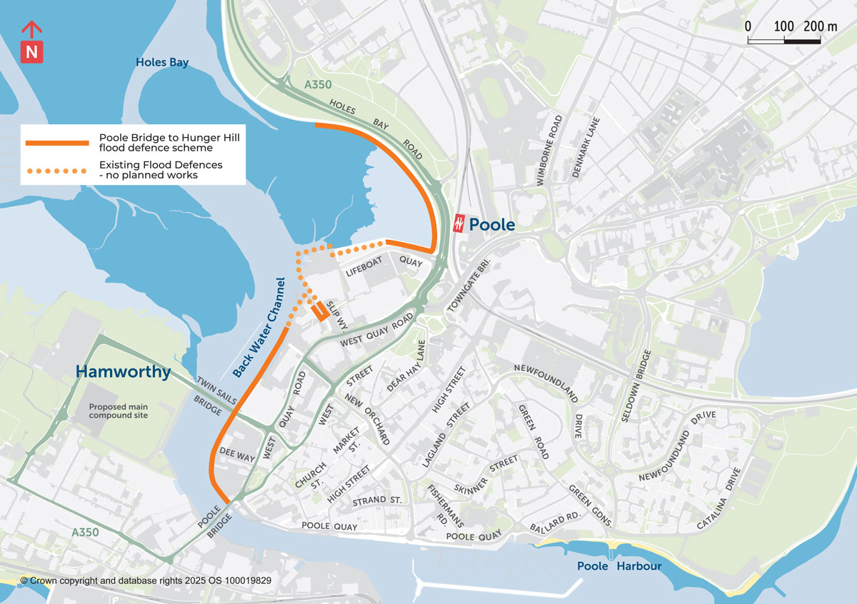
Poole Bridge to Hunger Hill is the last remaining undefended waterfront in the town centre. There is a high and present day risk of tidal flooding which increases significantly over the next century due to climate change and sea level rise. BCP Council, in collaboration with the Environment Agency, landowners, developers and other relevant organisations, is working to provide a continuous flood defence delivered in a single phase along 1.5 km of the eastern side of Holes Bay (see the Area map below).
Preparatory Works and Site Activity
Holes Bay is a highly protected area due to the presence of migratory birds, breeding fish, and seahorses. These protections restrict when works can be undertaken.
Following the granting of planning permission in July 2025, our ambition was to commence the heavy civil engineering works in Zone A from September and Zone E from October ’25. We are currently progressing the discharge of environmental and planning conditions, in accordance with the regulatory requirements. Once these are complete, the dates and timelines of the re-programmed heavy works will be confirmed around the environmental constraints.
Meanwhile, preparatory activities will continue, including deliveries to compound sites, surveys, and investigations. Site working hours are Monday – Friday 08:00-18:00. Set up for the day’s activities will start from 07:00. If required, Saturday working will take place between 08:00-13:00. Noise and vibration will be monitored during piling works to ensure it is kept within acceptable limits.
Holes Bay Path to Lifeboat Quay (Zone A)
The flood defence scheme will blend in with high ground at both ends of Zone A, near Sterte Avenue West on the A350 and at the Aqua Apartments on Lifeboat Quay. Generally, the Holes Bay path will be raised and widened, and the rock revetment will be upgraded. At certain pinch points (where the path cannot be raised), sheet piles will be installed adjacent to the rock revetment. Surface water from the new path will be directed to the grassed area. The raised Holes Bay path will gradually slope down to the existing pedestrian crossings on Holes Bay Road and Lifeboat Quay.
Along Lifeboat Quay, the new defences will run parallel to the road rather than on the water’s edge. This avoids SSEN’s high voltage electricity cables which supply Poole. Two flood gates will be installed: one on the corner of Asda’s water side path and one at the existing zebra crossing. Both gates will be closed when risk of flooding is high and allows easy access during normal conditions.
RNLI Car Park to Poole Bridge (Zone E)
A full-height, steel tubular and sheet-piled wall, designed to withstand tidal forces over the next 100 years, will be constructed from the RNLI car park to Poole Bridge. Flood gates or special defence features will be installed to enable businesses and clubs to continue to operate. They will be sealed when flood risk is high. Pontoons moved for construction will be re-instated. The installation of steel piles will take place from a barge on the water.
Flood defence scheme explainer video
Project news & milestones to date
Holes Bay Road traffic management, August-September
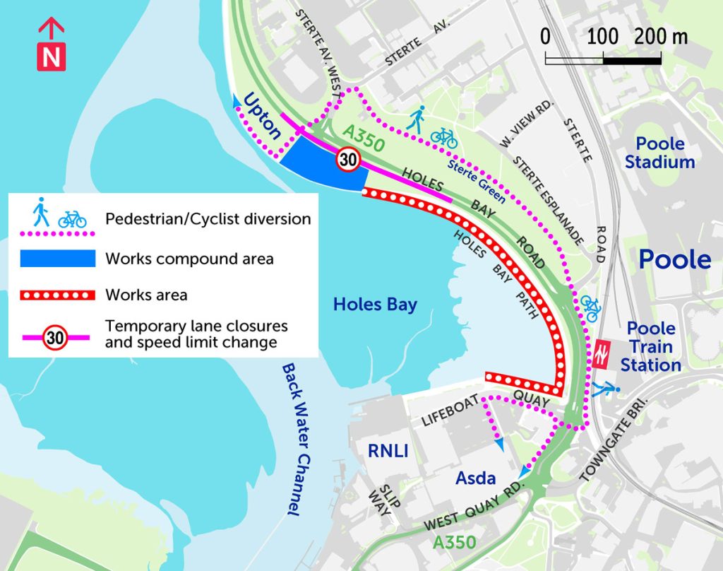

Pedestrian / Cyclist diversion
The Holes Bay path is temporarily closed for the duration of the flood defence construction and rock revetment upgrade. For safety reasons, a pedestrian and cyclist diversion is in place via Sterte Avenue West and Sterte Green to Poole Railway Station.
Holes Bay Road traffic management
Aug’25 – Feb’26 A temporary lane closure is in place at the works compound area on the northbound highway of the A350, near the junction with Sterte Avenue West. Additional off-peak lane closures will take place between 09:00 – 15:30 as required. The speed limit is reduced from 40mph to 30mph.
Compound site set-up and vegetation clearance, August
Site set-up took place through August. Before construction begins, vegetation clearance took place at Lifeboat Quay involving the removal of several trees and self-seeded plants to make room for the new flood defences. Following construction, new low maintenance coastal planting will be introduced. At the compound site, grass has been removed to create a safe hard standing for cabins and construction vehicles and equipment. It will be re-instated when the flood defence work is finished.
Planning approval, July 2025
Consent to build the new flood defence infrastructure along Zones A and E was granted on 18 July 2025 – ref APP/24/01215/F
Highway works at the Slip Way (Zone C) completed July 2025
May – July 2025 the highway around the harbour access point between the RNLI buildings was raised to reduce flood risk for the next 50 years. New marine vessel storage racks have been installed to accommodate the altered flood defence height. Our thanks to the RNLI and Poole Harbour Association for working closely with us to keep disruption to a minimum. Works to the highway did not require planning permission.
Proud to support Outdoor Classroom Day, May 2025

The event was led by Dorset Coast Forum. Outdoor Classroom Day is a global movement to inspire outdoor play and learning.
Public Consultation, September 2024
During our consultation period, we asked for views on the impacts of the proposed scheme and how we might minimise any disruption during construction.
- BCP residents were invited to complete an online survey (or a paper version available in all BCP libraries). Meetings with directly affected stakeholders continued during this time. An Information Document was provided to help everyone understand our proposals.
- We held a drop-in event on Thurs 5 September (10am – 4.30pm) at Scouts Hall West Quay Road, Poole. Thanks to all of those who turned out in the rain to read our display panels and talk to the team.
- We also held an online presentation and Q&A session on Wed 11 September (6.45 – 8.00pm). If you missed it, a video recording is still available to view at YouTube.
Feedback from our public consultation (Have Your Say | BCP Council) and stakeholder meetings was analysed during in October. Based on community feedback, adjustments were made to the design, including the incorporation of additional flood gates to maintain access for businesses and the public, and modifications to the landscaping plan to enhance the visual appeal of the flood defences” – for more information please see the Statement of Community Involvement (section 4.3) and how it informed the Planning Application submitted in November 2024. Stakeholder meetings will continue throughout planning and construction.
Scheme maps
Area map
Flood Defence Scheme, Area Map
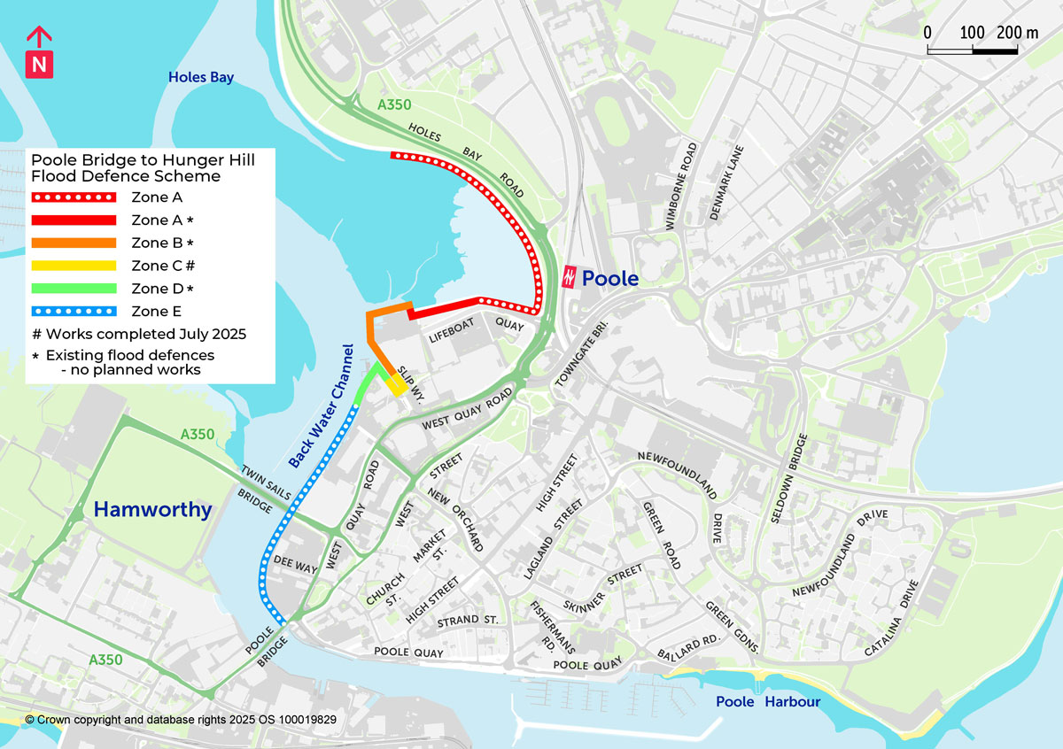
Zones map
Flood Defence Scheme, Zones map
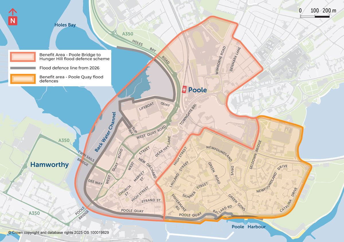
Benefits map
Flood Defence Scheme, Benefits Map
Flood risk in Poole
The Poole Harbour and Wareham, Flood and Coastal Erosion Risk Management Strategy (2014) identified that within Central Poole there are 573 properties at high flood risk in the present day, rising to over 2,000 properties at flood risk by 2110. In recognition that regeneration was not forthcoming to provide the flood defences, we tabled the option of a Council-led scheme and it gained outline business case approval by BCP Cabinet in September 2020. Initial funding from the Environment Agency was awarded to the proposed scheme in January 2021 [more].
The land along Back Water Channel is in a mixture of different private ownerships. The current quay walls simply retain the earth and are not considered to be flood defence infrastructure. Many do not have a crest level higher than the land behind and some require urgent attention.
Scheme benefits
The benefits of a flood defence scheme, delivered in a single phase, include:
- Mitigating the increasing risk of flooding to people and property, caused by climate change over the next 100 years.
- Contributing positively to public health and well-being by reducing the mental and emotional stress of flooding; as well as the risk to life.
- Improving and enhancing the condition or integrity of the local environmentally designated sites and marine habitats.
- Unlocking land for future redevelopment by private landowners where buildings are expected to provide vibrant ground-floor frontages for businesses and new homes for local people on the upper floors.
- Creating new public quayside and waterfront routes in Poole Harbour for leisure, exercise and commuter use, positively contributing to the areas sustainability.
Potential costs of flood damage without defences
Without the flood defence scheme, the potential cost of tidal flooding damages to town centre infrastructure and properties, over the next 100 years, could exceed £161 million. This is the area highlighted in red on the Benefits map above. By calculating the cost of damages in a ‘do nothing’ scenario it enables us to bid for central government Grant in Aid funding so that we can do something to reduce the flood risk to local communities. The adjacent area (highlighted orange on the map) shows the area which was used to gain funding for the raising of Poole Quay’s flood defences.

Example of the poor condition of the current quay walls
Example of the poor condition of the current quay walls

Example of the very low level and poor condition of the current quay walls
Example of the very low level and poor condition of the current quay walls
An adaptable design
The scheme is split into five zones, see the Zones map above. Each has different interventions planned for 2025, 2071 and 2105 so that the sea wall levels keep pace with climate change. BCP Council intends to take ownership and maintenance liability for the new flood defence. This is an important aspect of ensuring we can maintain and adapt it in the future.
- Zone A – Holes Bay Path & Lifeboat Quay Defences will be raised to 2.65m AOD* in 2025, then raised again to 3.6m AOD in 2071.
- Zone B – RNLI All Weather Lifeboat Station is protected for the next 85 years. No planned works.
- Zone C – Slip Way will make best use of existing assets. Ground levels will be raised to 2.49m AOD* in 2025 and then raised again to 3.6m AOD in 2071.
- Zone D – RNLI College is protected for the next 50 years. No planned works.
- Zone E – RNLI car park to Poole Bridge. It is more cost effective to replace the current quay walls in 2026, raising the height to 3.6m AOD*.
*Above Ordnance Datum (AOD) is a fixed reference level (in Newlyn, Cornwall) which has replaced ‘above sea level’ as the standard reference from which vertical heights on maps are measured.

A flood event at West Quay Road by Poole Bridge, 2008
A flood event at West Quay Road by Poole Bridge, 2008

Tidal water overtopping the sea wall at Lifeboat Quay, 2008
Tidal water overtopping the sea wall at Lifeboat Quay, 2008
Environmental considerations
The flood defence scheme is in Poole Harbour which has a range of protected special designations including: Ramsar – wetland sites of international importance, Site of Special Scientific Interest (SSSI) and Special Protection Area (SPA). To carry out any work in the Harbour, a number of environmental assessments are required from Natural England, Marine Management Organisation as well as planning consent from BCP Council. Anticipated environmental marine enhancements include benefits for wintering and breeding birds, breeding fish and seahorses & sea sponges.
Funding allocations
The construction cost for the flood defence scheme, delivered in a single phase, is approx. £29.4 million.
The Scheme secured £22.1 million of Flood & Coastal Erosion Risk Grant in Aid from Central Government including:
- £12.4 million from the Environment Agency in January 2021 (at the Outline Business Case stage)*
- £3.5 million from Defra in February 2025, when it announced funding for nearly 1,000 UK projects to protect properties most at risk from tidal flooding.
- £6.2 million from the Environment Agency in additional Grant in Aid funding in June 2025 (following detailed design)*
In June 2025, BCP Council considered the Strategic Prioritisation of Community Infrastructure Levy (CIL) and allocated this principal scheme £7.3 million.
*Variation in costs is a normal part of scheme design and delivery, increasing from the initial outline costs to a more accurately costed scheme by the end of the detailed design stage. However, the early estimated costs were subject to very significant increases due to Covid-19 and rapid inflation which greatly impacted the price of concrete and steel. The estimated construction costs were revised to circa £29.4 million at the end of detailed design. Approvals for cost increases were subject to the normal Grant in Aid scrutiny, with the business case still representing good value for money due to the significant flood risk across Poole town centre and unlocking of land for development.
Community Infrastructure Levy (CIL)
CIL can be used to fund a wide range of infrastructure including transport, flood defences, schools, hospitals, and other health and social care facilities. Under Section 216(2) of the Planning Act 2008 and regulation 59, Local Authorities must spend the levy on infrastructure needed to support development. More info at BCP | Community Infrastructure Levy
More
Once constructed, this new infrastructure will complete flood defences for Poole town centre, the Old Town and surrounding areas. Other schemes include: