SHORELINE MANAGEMENT PLAN (SMP)
Poole & Christchurch Bays
National SMP Explorer website launches
On 30 January 2024, the Environment Agency launched a new website to bring together all of the UK’s Shoreline Management Plans (SMPs). The information below will be updated to reduce duplication across these sites.
Background
Until relatively recently, coastal defences were constructed on an ad-hoc basis over relatively short lengths of coastline the boundaries of which were usually marked by administrative borders – an approach which failed to consider the impact on other coastlines and often resulted in erosion and flood problems downdrift.
In 1994 the Coastal Groups and local authorities of England & Wales were encouraged by Government to adopt the concept of Shoreline Management Plans (SMPs), with a view to providing a more strategic and sustainable approach to coastal defence.
An SMP sets out the policy for managing a length of coastline in response to the threat of coastal flooding and the risks of erosion. It is a high level non-statutory policy document that aims to balance those risks with natural processes and the consequences of climate change. It needs to take account of existing defences and the natural and built environments, and be compatible with adjacent coastal areas.
The local SMP (SMP2)
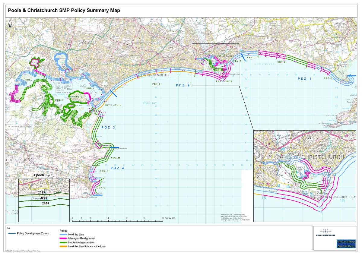
Poole and Christchurch Bays SMP covers the 190km (118 miles) of open coast, harbours, estuaries and headlands between Durlston Head in the west and Hurst Spit to the east, and includes the coastal communities of Swanage, Studland, Poole, Bournemouth, Christchurch, Highcliffe, Barton-on-Sea and Milford-on-Sea.
The first local SMP (SMP1) was produced in 1999. SMP2, published late October 2010, was the first review of that document. SMP2 promotes management policies for our coastline for 20, 50 and 100 years; providing a timeline for objectives, policy and management changes; i.e. a ‘route map’ for decision makers to move from the present situation towards the future.
The Plan divides the our length of coastline into four ‘Policy Development Zones’ (PDZs). PDZ boundaries are not recognised as hard lines, but solely as a practical means of examining the coast in detail. Within the PDZs individual Policy Units have been developed.
It goes on to identify one of four shoreline management policies for each Policy Unit:
- Hold the Line – maintain / upgrade / replace coastal defences in their current position where funding permits.
- Managed Realignment – manage coastal processes to realign the ‘natural’ coastline configuration, either seaward or landward of its present position.
- No Active Intervention (do nothing) – a decision not to invest in providing or maintaining defences or management of the coast.
- Advance the Line – a decision to build new defences seaward of the existing defence line where significant land reclamation is considered.
A summary of each of the shoreline management policies for the local SMP Policy Units are indicated on the map below.
Important note:
The SMP is a policy document which makes recommendations for action. Implementation of the Action Plan* will depend on available funding.
There is no guarantee that such funding will be forthcoming. It may be available from the national flood and coastal erosion risk management budget, but it could also come from other national sources or from local and/or third party funding.
* The Action Plan and all other documentation relating to SMP2 can be found at www.twobays.net/smp2.htm
A 2017 SMP review by the Environment Agency found nearly a third of management policies contained in them require attention, of which about half may be undeliverable as they stand.
An ‘SMP Refresh’ commenced in 2019, using a series of review and development activities to make sure the Plans are up to date, reliable and visible, and ensure onward maintenance is easier. The SMP Refresh will ensure SMPs are and remain ‘living’ documents.”
Background
Until relatively recently, coastal defences were constructed on an ad-hoc basis over relatively short lengths of coastline the boundaries of which were usually marked by administrative borders – an approach which failed to consider the impact on other coastlines and often resulted in erosion and flood problems downdrift.
In 1994 the Coastal Groups and local authorities of England & Wales were encouraged by Government to adopt the concept of Shoreline Management Plans (SMPs), with a view to providing a more strategic and sustainable approach to coastal defence.
An SMP sets out the policy for managing a length of coastline in response to the threat of coastal flooding and the risks of erosion. It is a high level non-statutory policy document that aims to balance those risks with natural processes and the consequences of climate change. It needs to take account of existing defences and the natural and built environments, and be compatible with adjacent coastal areas.
The local SMP (SMP2)
Poole and Christchurch Bays SMP covers the 190km (118 miles) of open coast, harbours, estuaries and headlands between Durlston Head in the west and Hurst Spit to the east, and includes the coastal communities of Swanage, Studland, Poole, Bournemouth, Christchurch, Highcliffe, Barton-on-Sea and Milford-on-Sea.
The first local SMP (SMP1) was produced in 1999. SMP2, published late October 2010, was the first review of that document. SMP2 promotes management policies for our coastline for 20, 50 and 100 years; providing a timeline for objectives, policy and management changes; i.e. a ‘route map’ for decision makers to move from the present situation towards the future.
The Plan divides the our length of coastline into four ‘Policy Development Zones’ (PDZs). PDZ boundaries are not recognised as hard lines, but solely as a practical means of examining the coast in detail. Within the PDZs individual Policy Units have been developed.
It goes on to identify one of four shoreline management policies for each Policy Unit:
- Hold the Line – maintain / upgrade / replace coastal defences in their current position where funding permits.
- Managed Realignment – manage coastal processes to realign the ‘natural’ coastline configuration, either seaward or landward of its present position.
- No Active Intervention (do nothing) – a decision not to invest in providing or maintaining defences or management of the coast.
- Advance the Line – a decision to build new defences seaward of the existing defence line where significant land reclamation is considered.
A summary of each of the shoreline management policies for the local SMP Policy Units are indicated on the map below.
Important note:
The SMP is a policy document which makes recommendations for action. Implementation of the Action Plan* will depend on available funding.
There is no guarantee that such funding will be forthcoming. It may be available from the national flood and coastal erosion risk management budget, but it could also come from other national sources or from local and/or third party funding.
* The Action Plan and all other documentation relating to SMP2 can be found at www.twobays.net/smp2.htm
A 2017 SMP review by the Environment Agency found nearly a third of management policies contained in them require attention, of which about half may be undeliverable as they stand.
An ‘SMP Refresh’ commenced in 2019, using a series of review and development activities to make sure the Plans are up to date, reliable and visible, and ensure onward maintenance is easier. The SMP Refresh will ensure SMPs are and remain ‘living’ documents.”


The SMP was prepared by a Client Steering Group (CSG) comprising representatives from: New Forest District Council • Christchurch Borough Council, Bournemouth Borough Council and Borough of Poole (now collectively BCP Council) • Purbeck District Council • Environment Agency
Also on the CSG were five associate partners: Natural England • National Trust • Dorset County Council • Hampshire County Council • Poole Harbour Commissioners
The CSG commissioned consultant engineers Royal Haskoning to prepare the SMP. Funding was provided by the Department for Environment, Food and Rural Affairs (Defra).
Full details at www.twobays.net/smp2.htm