CURRENT PROJECT
Christchurch Bay and Harbour FCERM StrategyLead Authority
BCP Council
Project start date
July 2021
Last Updated
18 September 2023
Climate change is putting significantly more properties, infrastructure and open spaces at risk from coastal flooding and erosion. Calculations have revealed that if we do nothing over the next 100 years, the coastal frontage will suffer around £1 billion in damages which includes erosion risk to approximately 1,600 properties and coastal flood risk to over 2,200 properties (homes and non-residential buildings). The figures are not designed to alarm but to help us evidence and justify doing something to manage the risks.
A new coastal strategy
Bournemouth, Christchurch and Poole Council (BCP) and New Forest District Council (NFDC) are working together with the Environment Agency (EA) to produce a strategy for Christchurch Bay and Harbour. It will identify where, when and broadly what type of works are needed to manage the risks of coastal flooding and erosion over the next century and roughly what they may cost. It will also consider the effects of predicted climate change on coastal communities, including sea level rise and the increased frequency of storms.
As Coast Protection Authorities, BCP and NFDC do not have a statutory duty to undertake coast protection work, but we can use permissive powers to protect the coastline and work with communities to help them adapt to future coastal change. In addition, along with the EA, BCP (as Lead Local Flood Authority – LLFA) has statutory responsibilities for managing flood risk; Hampshire County Council is the LLFA covering the NFDC area.
Strategy area
The strategy area stretches immediately east of Hengistbury Head Long Groyne to the western end of Hurst Spit and encompasses Christchurch Harbour up to Tuckton Bridge on the River Stour and Knapp Mill on the River Avon.
We have divided the coastal frontage into six Strategic Management Zones (SMZs), as shown on the Strategy area map above. These help us to identify how we could manage the coastal flooding and erosion risks in each of the linked areas. Each of the SMZs are further divided into 18 Option Development Units (ODUs). These allow us to carry out an options appraisal process to consider how the local requirements of each area could be addressed.
We are also working collaboratively with the Hurst Spit to Lymington Strategy, which borders our strategy area to the east. The two strategies are linked by Hurst Spit, an important coastal feature and landmark of the area. By working together, Hurst Spit can be fully integrated into both strategies:
Funding
Producing the Strategy – In Autumn 2020, BCP Council successfully secured £525,000 of government Flood Defence Grant in Aid (FDGiA) to produce the strategy on behalf of the partners. We have appointed specialist technical consultant AECOM to help support us in this work.
Coast protection schemes – The final adopted Strategy will enable us to bid for government funding to deliver viable and realistic coast protection schemes to implement SMP policy. Although there is no guarantee we’d receive 100% funding for schemes, it will help us to understand the level of partnership funding that may be required to deliver a scheme.
Strategy development – engagement and consultation
We have involved our stakeholders in the development of the Strategy since summer 2021. You can read all of our engagement and consultation findings on the BCP Council Have your Say Christchurch Bay and Harbour Strategy Hub. You can also view the recording of the online presentation from 27 June 2023.
In Winter 2022, the public and key stakeholders had their say on the proposed short list for managing coastal flood and erosion risks. Each of the options were then appraised to assess their economic, technical, environmental and social viability. The process identified the proposed leading options for each of the 18 option development units across the strategy area. These proposals were the focus of the Phase 5 consultation which ran from 5 June to 27 August 2023. The feedback was considered used to inform the Draft Strategy.
Next steps
The Draft Strategy will be presented for adoption at:
- New Forest District Council’s Cabinet – Mid September 2024
- BCP Council’s Cabinet – Mid October 2024
It will then be presented to the Environment Agency’s Large Project Review Group for final adoption.
Coastal flood risk
Coastal properties, infrastructure and assets can be at risk from flooding ie during periods of high tides combined with storm surges and wave overtopping. Due to climate change, sea level is predicted to rise by 1.03m over the next 100 years. This will increase the risk of coastal flooding by making extreme coastal water levels higher and more frequent. Flooding caused by storm events is expressed in terms of an Average Return Period in years, calculating the frequency and intensity of past events. It describes the severity of a storm event and these can sometimes occur more than once in the same year. A large storm event that occurs on average once every century is referred to as a 1 in 100 year event.
Coastal erosion risk
Coastal properties, infrastructure and assets can be at risk from erosion, i.e. potentially being lost to the sea through shoreline retreat or land sliding. Shoreline retreat is where coastline boundaries change because of waves and tides, sediment supply, precipitation levels and the effect of groundwater. Sea level rise alone will also significantly increase the risk of coastal erosion. Our risk modelling data shows that if we do nothing and let nature take its course, our coastline would on average* erode by up to 1m every year.
*Cliffs in the strategy area are complex (influenced by both toe erosion and groundwater) and tend to undergo infrequent but large-scale episodes of retreat by cliff slips and landslides. The losses to this type of erosion are averaged out to give a yearly retreat figure.
Defending the coast
To reduce the effects of coastal erosion on communities and the natural environment, a combination of various defence structures and natural features can be used. These measures fall into two main categories:
- Hard engineering uses man-made barriers such as sea walls, groynes and rock revetments to reduce the impact of waves on the coast.
- Soft engineering techniques such as beach renourishment, dunes and saltmarsh creation use natural materials, features and processes to absorb energy from the waves.
Many successful coastal management methods combine both hard and soft engineering techniques. In each case the effects upon coastal processes and the natural environment are fully explored before management decisions are made.
Despite everything that can be done there will always be some locations where it is not possible or appropriate to defend against coastal flooding/erosion or maintain existing defences. In these cases, communities need time and support to adapt to changes. It is also important to note that although property insurance against coastal flooding can be purchased, there is no insurance currently available for coastal erosion.
Environmental considerations
Coastal management can have a significant impact on geological features, wildlife habitats, coastal processes, landforms and heritage features. The conservation of these habitats and features in a changing environment remains a key aspect in terms of environmental sustainability. Future management of the coast needs to allow natural habitats and features to respond and adjust to change, such as accelerated sea level rise. It must also comply with the legislation relating to important conservation designations protecting many habitats along the coastal frontage.
Poole Bay, Poole Harbour and Wareham FCERM Strategy
In 2014, the Poole Bay, Poole Harbour and Wareham Strategy was adopted by the Environment Agency and its partners to identify how coastal flood and erosion risks from Swanage to Hengistbury Head , encompassing Poole Harbour and Wareham would be managed over the next 100 years, with an emphasis on the years up to 2030. You can find out more about the schemes being guided by this Strategy as part of the Poole Bay Beach Management Scheme.

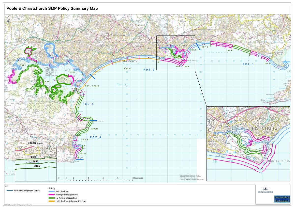
The policy balances the risks with natural processes by assigning one of four different management approaches to each of the coastline areas:
- Hold the Line – maintain / upgrade / replace coastal defences in their current position where funding permits.
- Managed Realignment – manage coastal processes to realign the ‘natural’ coastline configuration, either seaward or landward of its present position.
- No Active Intervention (do nothing) – a decision not to invest in providing or maintaining defences or management of the coast.
- Advance the Line – a decision to build new defences seaward of the existing defence line where significant land reclamation is considered.


